area
Plots a region on the plotting surface
specified by a string or array of numbers.
The area may be specified as an STC-S string
(as for example in an ObsCore or EPN-TAP
s_region column)
or using an array of numbers representing a
polygon, circle or point as flagged using the DALI/VOTable
extended type (xtype) marker,
or as an ASCII-encoded MOC.
Areas smaller than a configurable threshold size in pixels are by default represented by a replacement marker, so the position of even a very small area is still visible on the screen.
This plot type is generally intended for displaying relatively small shapes such as instrument footprints. It can be used for areas that are larger as well, but there may be issues with use, for instance auto-determination of the initial plot region may not work so well, and the rendering of shapes that are large relative to the sky may be inaccurate. These issues may be addressed in future releases.
Usage Overview:
   layerN=area polymodeN=outline|border|fill|cross|star thickN=<int-value>
               minsizeN=<pixels> minshapeN=filled_circle|open_circle|...
               shadingN=auto|flat|translucent|transparent|density|aux|weighted|paux|pweighted <shade-paramsN>
               areaN=<area-expr>
               areatypeN=POINT|CIRCLE|POLYGON|MOC-ASCII|UNIQ|STC-S|TFCAT
               inN=<table> ifmtN=<in-format> istreamN=true|false icmdN=<cmds>
All the parameters listed here
affect only the relevant layer,
identified by the suffix
N.
Example:
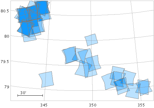
   stilts plot2sky reflectlon=false sex=false clon=348.9 clat=79.8 radius=1.0
                   in=crism.fits icmd='select sensor_id==0x4c'
                   area_p=s_region areatype_p=stc-s
                   layer_pf=area polymode_pf=fill color_pf=1199ff shading_pf=transparent
                   layer_pl=area polymode_pl=outline color_pl=grey
areaN = <area-expr> (String)
areatype parameter.
The value is a Area value algebraic expression based on column names as described in Section 10.
areatypeN = POINT|CIRCLE|POLYGON|MOC-ASCII|UNIQ|STC-S|TFCAT (AreaMapper)
areaN is supplied.
Options are:
POINT: 2-element array (x,y)CIRCLE: 3-element array (x, y, r)POLYGON: 2n-element array (x1,y1, x2,y2,...);
a NaN,NaN pair can be used to delimit distinct polygons.MOC-ASCII: Region description using ASCII MOC syntax;
see MOC 2.0 sec 4.3.2.
Note there are currently a few issues
with MOC plotting, especially for large pixels.UNIQ: Region description representing a single HEALPix cell
as defined by an UNIQ value, see
MOC 2.0
sec 4.3.1.STC-S: Region description using STC-S syntax;
see TAP 1.0, section 6.
Note there are some restrictions:
<frame>, <refpos> and <flavor> metadata are ignored,
polygon winding direction is ignored (small polygons are assumed)
and the INTERSECTION and NOT constructions are not supported.
The non-standard MOC construction is supported.TFCAT: Time-Frequency region defined by the
TFCat standard.
Support is currently incomplete;
holes in Polygons and MultiPolygons are not displayed correctly,
single Points may not be displayed,
and Coordinate Reference System information is ignored.
areaN value.
icmdN = <cmds> (ProcessingStep[])
inN.
The value of this parameter is one or more of the filter
commands described in Section 6.1.
If more than one is given, they must be separated by
semicolon characters (";").
This parameter can be repeated multiple times on the same
command line to build up a list of processing steps.
The sequence of commands given in this way
defines the processing pipeline which is performed on the table.
Commands may alternatively be supplied in an external file,
by using the indirection character '@'.
Thus a value of "@filename"
causes the file filename to be read for a list
of filter commands to execute. The commands in the file
may be separated by newline characters and/or semicolons,
and lines which are blank or which start with a
'#' character are ignored.
A backslash character '\' at the end of a line
joins it with the following line.
ifmtN = <in-format> (String)
inN.
The known formats are listed in Section 5.1.1.
This flag can be used if you know what format your
table is in.
If it has the special value
(auto) (the default),
then an attempt will be
made to detect the format of the table automatically.
This cannot always be done correctly however, in which case
the program will exit with an error explaining which
formats were attempted.
This parameter is ignored for scheme-specified tables.
[Default: (auto)]
inN = <table> (StarTable)
-",
meaning standard input.
In this case the input format must be given explicitly
using the ifmtN
parameter.
Note that not all formats can be streamed in this way.:<scheme-name>:<scheme-args>.<" character at the start,
or a "|" character at the end
("<syscmd" or
"syscmd|").
This executes the given pipeline and reads from its
standard output.
This will probably only work on unix-like systems.istreamN = true|false (Boolean)
inN parameter
will be read as a stream.
It is necessary to give the
ifmtN parameter
in this case.
Depending on the required operations and processing mode,
this may cause the read to fail (sometimes it is necessary
to read the table more than once).
It is not normally necessary to set this flag;
in most cases the data will be streamed automatically
if that is the best thing to do.
However it can sometimes result in less resource usage when
processing large files in certain formats (such as VOTable).
This parameter is ignored for scheme-specified tables.
[Default: false]
minshapeN = filled_circle|open_circle|... (MarkerShape)
minsize.
The available options are:
filled_circle
open_circle
cross
x
open_square
open_diamond
open_triangle_up
open_triangle_down
fat_circle
fat_cross
fat_x
fat_square
fat_diamond
fat_triangle_up
fat_triangle_down
filled_square
filled_diamond
filled_triangle_up
filled_triangle_down
[Default: x]
minsizeN = <pixels> (Integer)
[Default: 1]
polymodeN = outline|border|fill|cross|star (PolygonShape)
The available options are:
outline: draws a line round the outside of the polygonborder: draws a line butting up to the outside of the polygon; may look better for adjacent shapes, but more expensive to drawfill: fills the interior of the polygoncross: draws a line round the outside of the polygon and lines between all the verticesstar: draws a line round the outside of the polygon and lines from the nominal center to each vertex[Default: outline]
shadingN = auto|flat|translucent|transparent|density|aux|weighted|paux|pweighted <shade-paramsN> (ShapeMode)
[Default: auto]
thickN = <int-value> (Integer)
[Default: 0]